- P-ISSN2765-2203
- E-ISSN2765-2211
- KCI Candidate

6권 Special Issue호
초록
Cities are simultaneously vulnerable ecosystems exposed to risks such as heatwaves, floods, and air pollution, while also holding potential to drive biodiversity conservation and resilience. As cities play an increasingly critical role in achieving global biodiversity targets, the International Union for Conservation of Nature developed the Urban Nature Indexes (UNI) to assess urban ecological performance. This paper introduces the UNI methodology and discusses strategic directions for its application in Korea. The UNI is grounded in the Driving forces-Pressures-State-Impact-Response framework and the Urban Bioshed Impact Areas model, enabling assessment of ecological impacts within and beyond city boundaries. It comprises six themes and 30 indicator topics. For Korea, we highlight priorities including indicator localization, data infrastructure development, and policy integration. Applying the UNI in Korea is expected to strengthen national biodiversity strategies and position cities as active contributors to global sustainability agendas.
Abstract
Cities are simultaneously vulnerable ecosystems exposed to risks such as heatwaves, floods, and air pollution, while also holding potential to drive biodiversity conservation and resilience. As cities play an increasingly critical role in achieving global biodiversity targets, the International Union for Conservation of Nature developed the Urban Nature Indexes (UNI) to assess urban ecological performance. This paper introduces the UNI methodology and discusses strategic directions for its application in Korea. The UNI is grounded in the Driving forces-Pressures-State-Impact-Response framework and the Urban Bioshed Impact Areas model, enabling assessment of ecological impacts within and beyond city boundaries. It comprises six themes and 30 indicator topics. For Korea, we highlight priorities including indicator localization, data infrastructure development, and policy integration. Applying the UNI in Korea is expected to strengthen national biodiversity strategies and position cities as active contributors to global sustainability agendas.
초록
The global significance of nature-based solutions (NbS) is increasingly emphasized, yet practical and evidence-based guidance on defining and implementing effective NbS strategies remains limited. This review synthesizes findings from twenty key empirical studies that examine the role of urban green and blue spaces (GBS) in addressing two of the IUCN’s societal challenges: (1) climate change mitigation and adaptation, with a focus on urban heat reduction, and (2) disaster risk reduction, with a focus on urban flood mitigation. Evidence across the literature shows that GBS meaningfully reduce both surface temperatures and flood risks. The effectiveness of GBS is determined not only by expanding their coverage but also by designing interconnected ecological systems with optimized spatial configuration, vegetation structure, hydrological linkages, and by ensuring that they are positioned in the urban areas most vulnerable to heat and flooding. To enhance urban climate resilience, cities should adopt scale-appropriate design and placement strategies and integrate GBS within existing infrastructure networks. Future research should develop standardized performance metrics, assess long-term outcomes under climate change scenarios, and strengthen evidence-based urban planning that positions NbS as a central component of sustainable and resilient city development.
Abstract
The global significance of nature-based solutions (NbS) is increasingly emphasized, yet practical and evidence-based guidance on defining and implementing effective NbS strategies remains limited. This review synthesizes findings from twenty key empirical studies that examine the role of urban green and blue spaces (GBS) in addressing two of the IUCN’s societal challenges: (1) climate change mitigation and adaptation, with a focus on urban heat reduction, and (2) disaster risk reduction, with a focus on urban flood mitigation. Evidence across the literature shows that GBS meaningfully reduce both surface temperatures and flood risks. The effectiveness of GBS is determined not only by expanding their coverage but also by designing interconnected ecological systems with optimized spatial configuration, vegetation structure, hydrological linkages, and by ensuring that they are positioned in the urban areas most vulnerable to heat and flooding. To enhance urban climate resilience, cities should adopt scale-appropriate design and placement strategies and integrate GBS within existing infrastructure networks. Future research should develop standardized performance metrics, assess long-term outcomes under climate change scenarios, and strengthen evidence-based urban planning that positions NbS as a central component of sustainable and resilient city development.
초록
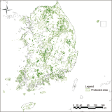
The Protected Connected land indicator (ProtConn) and the Species Protection Index (SPI) are adopted under Target 3 of the Kunming–Montreal Global Biodiversity Framework to represent structural connectivity and species-level conservation outcomes, respectively. However, empirical evidence linking ProtConn to observed biodiversity outcomes remains limited. This study synthesizes ecological theory, international policy frameworks, and existing literature to clarify the conceptual relationship between ProtConn and SPI and to assess the feasibility of future empirical linkage analyses. The results indicate that ProtConn primarily functions as a structural condition indicator describing protected area network configuration, whereas SPI captures biological conservation outcomes, highlighting a clear distinction between structural conditions and ecological responses. Furthermore, this study demonstrates that nationally standardized biodiversity datasets in the Republic of Korea are spatially and taxonomically compatible with ProtConn-based analyses. These findings identify critical empirical gaps and provide a methodological foundation for future quantitative research examining the relationship between protected area connectivity and biodiversity conservation outcomes.
Abstract
The Protected Connected land indicator (ProtConn) and the Species Protection Index (SPI) are adopted under Target 3 of the Kunming–Montreal Global Biodiversity Framework to represent structural connectivity and species-level conservation outcomes, respectively. However, empirical evidence linking ProtConn to observed biodiversity outcomes remains limited. This study synthesizes ecological theory, international policy frameworks, and existing literature to clarify the conceptual relationship between ProtConn and SPI and to assess the feasibility of future empirical linkage analyses. The results indicate that ProtConn primarily functions as a structural condition indicator describing protected area network configuration, whereas SPI captures biological conservation outcomes, highlighting a clear distinction between structural conditions and ecological responses. Furthermore, this study demonstrates that nationally standardized biodiversity datasets in the Republic of Korea are spatially and taxonomically compatible with ProtConn-based analyses. These findings identify critical empirical gaps and provide a methodological foundation for future quantitative research examining the relationship between protected area connectivity and biodiversity conservation outcomes.
초록
This study presents an integrated decision-making matrix linking the International Union for Conservation of Nature (IUCN) Red List of Ecosystems (RLE) assessment framework with Nature-based Solutions (NbS) societal challenges for 36 ecosystem types defined in South Korea. We developed systematic mapping rules between RLE threat categories (land use change, hydrological modification, climate change, pollution, overexploitation, and invasive species) and seven NbS contribution areas (climate mitigation, climate adaptation, disaster risk reduction, water security, food security, biodiversity, and socioeconomic development). Our analysis revealed that wetland, estuarine, and coastal ecosystems under hydrological modification and reclamation pressure prioritize water security and disaster risk reduction-centered NbS; forest, grassland, and agricultural ecosystems experiencing fragmentation and conversion pressure prioritize biodiversity and socioeconomic/food security-centered NbS; and climate-vulnerable montane and cryogenic ecosystems prioritize climate adaptation and disaster risk reduction-centered NbS. The matrix proposes 2-3 core operational indicators for each ecosystem type to enhance implementation and monitoring practicality, and when combined with RLE risk assessments, can serve as a tool to strengthen objectivity in policy priority decisions. By presenting a national-level standardized framework linking ecosystem threat diagnosis with solution application, this study is expected to contribute to evidence-based ecosystem management policy development.
Abstract
This study presents an integrated decision-making matrix linking the International Union for Conservation of Nature (IUCN) Red List of Ecosystems (RLE) assessment framework with Nature-based Solutions (NbS) societal challenges for 36 ecosystem types defined in South Korea. We developed systematic mapping rules between RLE threat categories (land use change, hydrological modification, climate change, pollution, overexploitation, and invasive species) and seven NbS contribution areas (climate mitigation, climate adaptation, disaster risk reduction, water security, food security, biodiversity, and socioeconomic development). Our analysis revealed that wetland, estuarine, and coastal ecosystems under hydrological modification and reclamation pressure prioritize water security and disaster risk reduction-centered NbS; forest, grassland, and agricultural ecosystems experiencing fragmentation and conversion pressure prioritize biodiversity and socioeconomic/food security-centered NbS; and climate-vulnerable montane and cryogenic ecosystems prioritize climate adaptation and disaster risk reduction-centered NbS. The matrix proposes 2-3 core operational indicators for each ecosystem type to enhance implementation and monitoring practicality, and when combined with RLE risk assessments, can serve as a tool to strengthen objectivity in policy priority decisions. By presenting a national-level standardized framework linking ecosystem threat diagnosis with solution application, this study is expected to contribute to evidence-based ecosystem management policy development.
초록
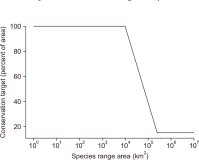
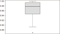
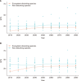
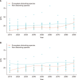
This study assessed changes in the Species Protection Index (SPI) for reptiles in the Republic of Korea under climate change. We integrated nationwide survey data to build species distribution models (SDM) for 18 reptile species and assessed their potential habitats under current and future climate scenarios (Shared Socioeconomic Pathway [SSP]: SSP2-4.5 and SSP5-8.5). The SDM performed well, with a mean area under the curve of 0.965 (range 0.869-0.999). By overlaying the predicted potential habitats with protected areas, we calculated Species Protection Scores for individual species and a taxon-level SPI for reptiles. The current SPI was 26.74 when all species were included, and 28.16 when ecosystem-disturbing (invasive) species were excluded. When the Species Conservation Target was adjusted to reflect the Republic of Korea context, these increased to 36.62 and 38.53, respectively. Under both future scenarios, SPI values declined through the mid-century (~2050) and then increased again in the late century (2060-2090). Ecosystem-disturbing (invasive) species initially exhibited lower SPI values but tended to overtake non-invasive species in the long term, underscoring the need to manage their incursions within protected areas. Overall, the findings support designating additional climate-informed protected areas alongside national and global 30% expansion targets.
Abstract
This study assessed changes in the Species Protection Index (SPI) for reptiles in the Republic of Korea under climate change. We integrated nationwide survey data to build species distribution models (SDM) for 18 reptile species and assessed their potential habitats under current and future climate scenarios (Shared Socioeconomic Pathway [SSP]: SSP2-4.5 and SSP5-8.5). The SDM performed well, with a mean area under the curve of 0.965 (range 0.869-0.999). By overlaying the predicted potential habitats with protected areas, we calculated Species Protection Scores for individual species and a taxon-level SPI for reptiles. The current SPI was 26.74 when all species were included, and 28.16 when ecosystem-disturbing (invasive) species were excluded. When the Species Conservation Target was adjusted to reflect the Republic of Korea context, these increased to 36.62 and 38.53, respectively. Under both future scenarios, SPI values declined through the mid-century (~2050) and then increased again in the late century (2060-2090). Ecosystem-disturbing (invasive) species initially exhibited lower SPI values but tended to overtake non-invasive species in the long term, underscoring the need to manage their incursions within protected areas. Overall, the findings support designating additional climate-informed protected areas alongside national and global 30% expansion targets.
초록
This research was conducted to determine how Key Biodiversity Areas (KBAs), areas that make a critical contribution to global biodiversity conservation, can contribute to solving societal challenges through Nature-based Solutions (NbS). To this end, a total of 21 documents, including international academic journals and institutional reports, were analyzed. Cases were classified and organized according to the seven major types of societal challenges defined by the International Union for Conservation of Nature NbS Global Standard. The analysis revealed that KBA-based NbS contributes most extensively in the ‘environmental degradation and biodiversity loss’ domain, aligning with the fundamental purpose of KBAs being biodiversity conservation. This was followed by contributions to water security, climate change mitigation and adaptation, and economic and social development. Conversely, case accumulation was limited in some areas, such as human health and food security, likely due to the relatively recent establishment of KBA standards. In terms of research scale, most studies were conducted at a global scale, while regionally, the most active NbS application was reported in Asia and Africa. This research demonstrates that KBAs can function as core spatial platforms for NbS implementation beyond simple protected areas. It also suggests that KBAs hold significant strategic value for achieving international environmental goals, such as the Kunming-Montreal Global Biodiversity Framework and the Sustainable Development Goals.
Abstract
This research was conducted to determine how Key Biodiversity Areas (KBAs), areas that make a critical contribution to global biodiversity conservation, can contribute to solving societal challenges through Nature-based Solutions (NbS). To this end, a total of 21 documents, including international academic journals and institutional reports, were analyzed. Cases were classified and organized according to the seven major types of societal challenges defined by the International Union for Conservation of Nature NbS Global Standard. The analysis revealed that KBA-based NbS contributes most extensively in the ‘environmental degradation and biodiversity loss’ domain, aligning with the fundamental purpose of KBAs being biodiversity conservation. This was followed by contributions to water security, climate change mitigation and adaptation, and economic and social development. Conversely, case accumulation was limited in some areas, such as human health and food security, likely due to the relatively recent establishment of KBA standards. In terms of research scale, most studies were conducted at a global scale, while regionally, the most active NbS application was reported in Asia and Africa. This research demonstrates that KBAs can function as core spatial platforms for NbS implementation beyond simple protected areas. It also suggests that KBAs hold significant strategic value for achieving international environmental goals, such as the Kunming-Montreal Global Biodiversity Framework and the Sustainable Development Goals.
초록
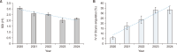
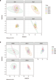
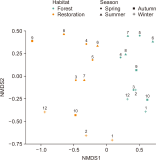
This study aimed to investigate the long-term dynamics of Sicyos angulatus communities, an invasive alien vine that threatens riparian biodiversity in Korea, and to provide baseline information for effective management strategies. Field surveys were conducted annually from 2020 to 2024 at four sites along the Han and Nakdong Rivers. At each site, the distribution area, importance value, and Shannon–Wiener diversity index were measured. The distribution area of S. angulatus fluctuated across years and sites, with temporary decreases followed by renewed expansion at some locations. Regardless of area changes, the species consistently increased in importance within plant communities, while species diversity declined, indicating progressive simplification and homogenization of riparian vegetation. NMDS ordination confirmed these structural changes and revealed significant effects of both year and site on community composition, confirming that S. angulatus drives structural shifts across temporal and spatial scales. These findings indicate that the ecological impact of S. angulatus extends beyond spatial expansion, encompassing increased dominance and the degradation of native plant diversity and resilience. Therefore, management strategies should address not only the control of its spatial spread but also the restoration of community structure through integrated removal, revegetation, and monitoring efforts.
Abstract
This study aimed to investigate the long-term dynamics of Sicyos angulatus communities, an invasive alien vine that threatens riparian biodiversity in Korea, and to provide baseline information for effective management strategies. Field surveys were conducted annually from 2020 to 2024 at four sites along the Han and Nakdong Rivers. At each site, the distribution area, importance value, and Shannon–Wiener diversity index were measured. The distribution area of S. angulatus fluctuated across years and sites, with temporary decreases followed by renewed expansion at some locations. Regardless of area changes, the species consistently increased in importance within plant communities, while species diversity declined, indicating progressive simplification and homogenization of riparian vegetation. NMDS ordination confirmed these structural changes and revealed significant effects of both year and site on community composition, confirming that S. angulatus drives structural shifts across temporal and spatial scales. These findings indicate that the ecological impact of S. angulatus extends beyond spatial expansion, encompassing increased dominance and the degradation of native plant diversity and resilience. Therefore, management strategies should address not only the control of its spatial spread but also the restoration of community structure through integrated removal, revegetation, and monitoring efforts.
초록
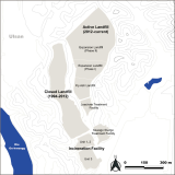
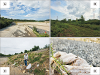
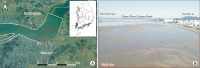
Global trade has facilitated invasive species introductions, both intentional and accidental, with soil translocation emerging as a key vector. This study focuses on the potential spread of Melanoplus differentialis (M. differentialis), an invasive North American grasshopper first detected in Ulsan, South Korea, in 2018. By 2020 it was designated an ecosystem-disturbing species, prompting habitat monitoring. In 2024, concerns arose that soil relocation during construction at a high-density outbreak site (Onsan Industrial Park) could inadvertently spread M. differentialis to the Seongam Municipal Landfill (Ulsan), where construction debris was moved. Surveys conducted at the landfill in May and September 2025 found no M. differentialis, only native grasshopper species. This absence may be due to egg masses being destroyed during construction or insufficient time for a population to establish after introduction. The findings underscore the importance of continued monitoring at translocation sites, as invasive grasshopper populations can proliferate rapidly even from low-level introductions. The results highlight the effectiveness of Early Detection and Rapid Response (EDRR) efforts in preventing the spread of M. differentialis beyond its initial habitat. Collaboration between the National Institute of Ecology, local government, and private sectors has successfully contained the species within its original site. This study underscores the need for vigilance and coordinated action in managing invasive species, especially those spread through human activities like soil and waste movement.
Abstract
Global trade has facilitated invasive species introductions, both intentional and accidental, with soil translocation emerging as a key vector. This study focuses on the potential spread of Melanoplus differentialis (M. differentialis), an invasive North American grasshopper first detected in Ulsan, South Korea, in 2018. By 2020 it was designated an ecosystem-disturbing species, prompting habitat monitoring. In 2024, concerns arose that soil relocation during construction at a high-density outbreak site (Onsan Industrial Park) could inadvertently spread M. differentialis to the Seongam Municipal Landfill (Ulsan), where construction debris was moved. Surveys conducted at the landfill in May and September 2025 found no M. differentialis, only native grasshopper species. This absence may be due to egg masses being destroyed during construction or insufficient time for a population to establish after introduction. The findings underscore the importance of continued monitoring at translocation sites, as invasive grasshopper populations can proliferate rapidly even from low-level introductions. The results highlight the effectiveness of Early Detection and Rapid Response (EDRR) efforts in preventing the spread of M. differentialis beyond its initial habitat. Collaboration between the National Institute of Ecology, local government, and private sectors has successfully contained the species within its original site. This study underscores the need for vigilance and coordinated action in managing invasive species, especially those spread through human activities like soil and waste movement.
초록
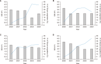
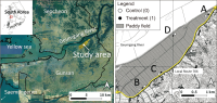
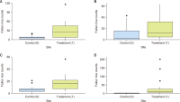
This study evaluated the effects of the rice straw retention project, implemented in Napo-myeon, Gunsan-si, under the payments for ecosystem services (PES) schemes, on providing food for wintering waterfowl. The amount of fallen rice was measured at four sites in both PES and non-PES fields. In all comparison pairs, the count of fallen rice grains in the PES fields was 3-11 times higher than in the non-PES fields (P<0.05). The effect size (r) ranged from 0.386 to 0.790, demonstrating substantial significance. This trend is consistent with similar studies conducted overseas. Therefore, the PES project appears to be achieving its intended goals, and these findings provide a foundation for the scientific evaluation of domestic PES policies.
Abstract
This study evaluated the effects of the rice straw retention project, implemented in Napo-myeon, Gunsan-si, under the payments for ecosystem services (PES) schemes, on providing food for wintering waterfowl. The amount of fallen rice was measured at four sites in both PES and non-PES fields. In all comparison pairs, the count of fallen rice grains in the PES fields was 3-11 times higher than in the non-PES fields (P<0.05). The effect size (r) ranged from 0.386 to 0.790, demonstrating substantial significance. This trend is consistent with similar studies conducted overseas. Therefore, the PES project appears to be achieving its intended goals, and these findings provide a foundation for the scientific evaluation of domestic PES policies.
초록
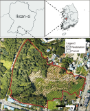
Although urban ecological restoration projects are actively implemented in response to urbanization, research evaluating their ecological effects in relation to adjacent natural ecosystems remains limited. This study assessed the ecological impacts of an urban restoration project by comparing wild bird assemblage structures between the Mt. Sorasan Nature Garden (Jayeon-madang) project, an urban ecological restoration site in Iksan, South Korea, and its adjacent existing forest. The restoration site, in its early post-construction phase, had approximately 45% of its area planted with woody species, including pines. Wild bird surveys were conducted in both habitats over one year (May 2017-April 2018), followed by statistical analysis. Results showed significant differences in bird assemblage structure between the sites (permutational multivariate analysis of variance, P<0.001). The adjacent forest, supported by a stable, long-established woodland, exhibited higher species diversity (H’=3.07) and was characterized by foliage gleaners (e.g., Paridae) and bark/trunk foragers (e.g., Picidae). In contrast, the restoration site, with small trees and insufficient cover due to its recent establishment, had lower species diversity (H’=2.38) and limited influx of forest-dwelling birds. However, its open grasslands and wetlands provided feeding and resting habitats for aquatic and ground-foraging birds. In conclusion, although the early-stage restoration site remains functionally limited as a forest, it complements the adjacent forest by creating heterogeneous habitats, thereby enhancing overall urban avian diversity. This study highlights the need for future restoration efforts to extend beyond simple tree planting and incorporate long-term habitat management that accounts for vegetation succession processes.
Abstract
Although urban ecological restoration projects are actively implemented in response to urbanization, research evaluating their ecological effects in relation to adjacent natural ecosystems remains limited. This study assessed the ecological impacts of an urban restoration project by comparing wild bird assemblage structures between the Mt. Sorasan Nature Garden (Jayeon-madang) project, an urban ecological restoration site in Iksan, South Korea, and its adjacent existing forest. The restoration site, in its early post-construction phase, had approximately 45% of its area planted with woody species, including pines. Wild bird surveys were conducted in both habitats over one year (May 2017-April 2018), followed by statistical analysis. Results showed significant differences in bird assemblage structure between the sites (permutational multivariate analysis of variance, P<0.001). The adjacent forest, supported by a stable, long-established woodland, exhibited higher species diversity (H’=3.07) and was characterized by foliage gleaners (e.g., Paridae) and bark/trunk foragers (e.g., Picidae). In contrast, the restoration site, with small trees and insufficient cover due to its recent establishment, had lower species diversity (H’=2.38) and limited influx of forest-dwelling birds. However, its open grasslands and wetlands provided feeding and resting habitats for aquatic and ground-foraging birds. In conclusion, although the early-stage restoration site remains functionally limited as a forest, it complements the adjacent forest by creating heterogeneous habitats, thereby enhancing overall urban avian diversity. This study highlights the need for future restoration efforts to extend beyond simple tree planting and incorporate long-term habitat management that accounts for vegetation succession processes.
초록
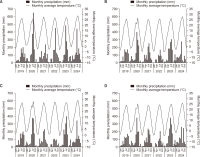
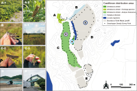
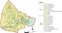
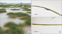
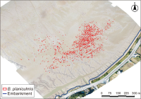
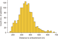
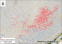
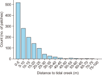
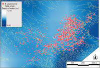
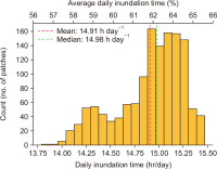
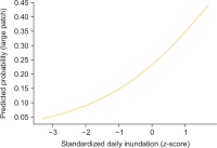
This study investigated the spatial distribution of the native halophyte Bolboschoenus planiculmis in the tidal wetlands of the Geum Estuary and analyzed its association with key hydrological factors. Based on drone imagery acquired in October 2024, a total of 1,344 patches were identified, covering a cumulative area of 13,754 m2. These patches were primarily concentrated at an average distance of 351 meters from the terrestrial embankment. While over 74% of patch centroids were located within 15 meters of tidal creeks, multivariate logistic regression analysis indicated that proximity to creeks did not have a statistically significant effect on patch size (P>0.05). In contrast, average daily inundation duration (15.2-18.9 hours/day, mean 17.6 hours) showed a significant positive correlation with the formation of larger patches (odds ratio=1.75, P<0.001), suggesting that inundation regime is a key driver of patch development. The findings highlight the species’ preference for mid-to lower-intertidal zones and underscore the importance of tidal and inundation management in formulating effective conservation and restoration strategies for halophytic plant habitats in estuarine ecosystems.
Abstract
This study investigated the spatial distribution of the native halophyte Bolboschoenus planiculmis in the tidal wetlands of the Geum Estuary and analyzed its association with key hydrological factors. Based on drone imagery acquired in October 2024, a total of 1,344 patches were identified, covering a cumulative area of 13,754 m2. These patches were primarily concentrated at an average distance of 351 meters from the terrestrial embankment. While over 74% of patch centroids were located within 15 meters of tidal creeks, multivariate logistic regression analysis indicated that proximity to creeks did not have a statistically significant effect on patch size (P>0.05). In contrast, average daily inundation duration (15.2-18.9 hours/day, mean 17.6 hours) showed a significant positive correlation with the formation of larger patches (odds ratio=1.75, P<0.001), suggesting that inundation regime is a key driver of patch development. The findings highlight the species’ preference for mid-to lower-intertidal zones and underscore the importance of tidal and inundation management in formulating effective conservation and restoration strategies for halophytic plant habitats in estuarine ecosystems.
초록
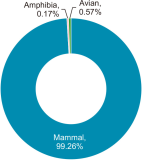
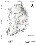
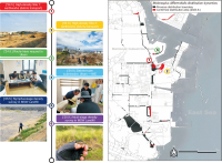
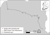
The Civilian Control Zone (CCZ) in South Korea is a highly restricted area with significant ecological value due to limited human access. This study explores the feasibility of non-invasive biodiversity monitoring using spider webs as environmental DNA (eDNA) collectors in the CCZ, particularly where traditional field surveys are constrained. A total of six spider webs were collected along the DMZ Peace Trail in Hwacheon-gun, Gangwon province, and subjected to eDNA metabarcoding using vertebrate-specific primers. Despite quality limitations in Q20 and Q30 scores, over two million reads were generated, and 531,429 high-quality reads were retained after filtering with the DADA2 pipeline. Taxonomic assignment using BLAST identified 13 vertebrate species, including nine mammals, two amphibians, and two birds. Comparative analysis with conventional field surveys revealed limited species overlap, but spider web eDNA successfully detected cryptic or rarely observed species, such as Rattus norvegicus and Felis catus. These findings suggest that spider web-derived eDNA offers potential as a complementary tool, especially in areas where direct observation is difficult or impossible due to safety or security concerns. However, incomplete reference databases and low detection efficiency highlight the need for improvements in sampling methods and local DNA libraries. This study presents a promising step toward developing alternative, non-invasive ecological monitoring techniques applicable to inaccessible terrestrial environments.
Abstract
The Civilian Control Zone (CCZ) in South Korea is a highly restricted area with significant ecological value due to limited human access. This study explores the feasibility of non-invasive biodiversity monitoring using spider webs as environmental DNA (eDNA) collectors in the CCZ, particularly where traditional field surveys are constrained. A total of six spider webs were collected along the DMZ Peace Trail in Hwacheon-gun, Gangwon province, and subjected to eDNA metabarcoding using vertebrate-specific primers. Despite quality limitations in Q20 and Q30 scores, over two million reads were generated, and 531,429 high-quality reads were retained after filtering with the DADA2 pipeline. Taxonomic assignment using BLAST identified 13 vertebrate species, including nine mammals, two amphibians, and two birds. Comparative analysis with conventional field surveys revealed limited species overlap, but spider web eDNA successfully detected cryptic or rarely observed species, such as Rattus norvegicus and Felis catus. These findings suggest that spider web-derived eDNA offers potential as a complementary tool, especially in areas where direct observation is difficult or impossible due to safety or security concerns. However, incomplete reference databases and low detection efficiency highlight the need for improvements in sampling methods and local DNA libraries. This study presents a promising step toward developing alternative, non-invasive ecological monitoring techniques applicable to inaccessible terrestrial environments.